
 [In this five-part Guest Post, military historian Charles Herrick pursues further the questions raised by conflicts between Capa’s own account (in Slightly Out of Focus) of his D-Day return trip from the Easy Red sector of Omaha Beach to the USS Samuel Chase (APA-26), which would take him and his films back to England.
Part 2 appears below. Click here for Part 1, and here for Part 3. — A.D.C.]
•
Leaving Omaha Beach:
Robert Capa Aboard LCI(L)-94 (2)
•
Context
… To understand the impossibility of Capa’s narratives, it is necessary to visualize the events in the context of time and space on that stretch of beach.
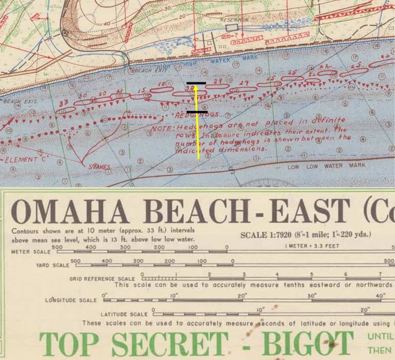
Figure 1. A detail of the invasion map prepared by Commander, TF 122 showing hydrographic and obstacle information for the Omaha Beach landings.
Figure 1 is a portion of the invasion map prepared by the US Navy. It shows part of the Easy Red Beach Sector. The yellow arrow indicates where LCI(L)-94 nosed in during its second beaching. The obstacle belt at this point was not as deep as elsewhere, because the outer row of obstacles (known as “Belgian gates”) had not been installed on this portion of the beach. The black lines show the approximate limits of the obstacle belt, which at that point consisted of stakes, log ramps and Czech hedgehogs.[1]
A section of the map’s legend is included to provide scale. From this we can see that the obstacle belt was a bit less than 100 yards deep at the point where LCI(L)-94 beached the second time.
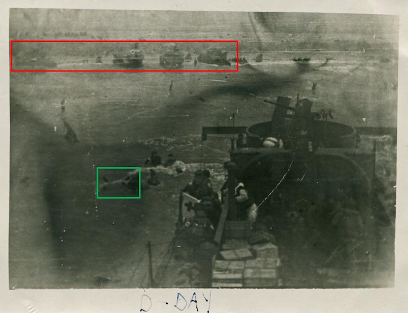
Figure 2. This photo shows LCI(L)-94 during its second beaching. The soldiers just off the port landing ramp are in water up to their shoulders. Capa, a short man, would have been covered at least as much as these men. This picture was snapped by Lt. Gislason, the ship’s captain, and donated to the National WWII Museum by the family of Charles Jarreau, a crewman of the ship.
Figure 2 shows LCI(L)-94 beached for the second time, with its bow even with the inner row of Czech hedgehog obstacles. The green box shows the top of one of those hedgehogs just poking above the water. From this we can determine the ship’s farthest location within the obstacle belt when it beached. Also, we can see the height of the water compared to both the men at the foot of the boarding ramp and the hedgehog obstacle.
This validates at least one part of Capa’s narrative: if he boarded after the medics debarked, then he would indeed have been immersed up to his neck.
Figure 3 provides an overview of LCI(L)-94‘s situation. With its bow grounded at the inner row of hedgehogs, and the ship being roughly 53 yards long, the entire length of the ship was within the obstacle belt. On the other hand, as the obstacle belt was no more than 100 yards deep at this point, the LCI’s stern was a bit less than 50 yards from clear water behind it. This means it would not need to retract very far before being able to swing about and head back out to sea.
Figure 3. A simplified view of the Easy Red beach sector at 0850 hours as LCI(L)-94 finished unloading troops. The symbols represent a general distribution of obstacles and do not attempt to place specific obstacles in individually accurate positions. (Author)
•
Now let’s establish four benchmarks within that area: 1) the time the ship was hit; 2) the ship’s orientation when it was hit the first time; 3) the ship’s orientation when it was hit the second time; and 4) the point at which Capa decided to leave the engine room and return above decks. We’ll then establish a fifth benchmark farther out to sea, where LCT-305 and the withdrawing LCI(L)-94 crossed paths.
Benchmark 1. The June 1944 Muster Roll for LCI(L)-94 documented the time of the casualties (0850 hours), which establishes when the ship was hit. We don’t know if that time was when the first or second shell hit, but since the hits came in rapid succession (as discussed below), it doesn’t matter.
Benchmarks 2 and 3. There’s a bit of confusion over the next two benchmarks, both based on the accounts of crew members. We know from my previous Damage Report post that the ship was hit twice (and perhaps a third time, but there is no pictorial proof of a third hit). Boatswain’s Mate 1st Class Marvin Graham was on duty at the boarding ramps. He stated, “We were off the beach and almost clear of all obstacles, when two hits from a field gun caught us.”[2]
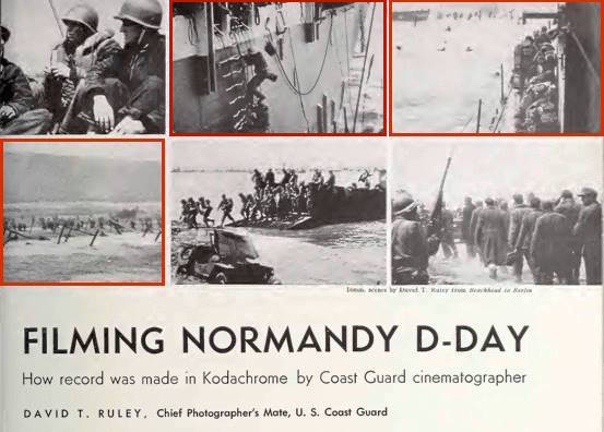
Fig. 8: Cinematographer David T. Ruley, illustrations for first-person account of D-Day experiences, Movie Makers magazine, 6/1/45
US Coast Guard cinematographer David T. Ruley gave a slightly different version in a 1945 article published in Movie Makers magazine.[3] He stated, “Just as the last of the troops had gone down the ramps and into the water, the ship was hit three times in rapid succession by an anti-tank gun from a shore battery on the beach.” This could be interpreted to mean that the ship was still beached when it was hit.
The “Damage Report” article provides insight into the ship’s positions when it was hit two times, based on pictorial evidence of the damage. From the location of the first hit, we can determine that the ship was pointed more or less directly at the beach when struck on the port side by a gun in the German Wn62 strongpoint.
But the shell hole from the second hit was on the front of the LCI’s pilothouse, indicating that the shell landed virtually perpendicular to the forward face of that structure. This means the ship had to have been facing almost directly at the gun position. And the LCI would only have been pointed in that direction if it were hit in the middle of the turn as it backed off the beach. So, I suggest, Ruley’s statement merely emphasized that the time between the last of the troops disembarking and the first of the hits was very short.
He could not have literally meant that the ship was still grounded on the sand when hit by both shells, because the damage from the second hit rules that out. By that logic, the ship was either still beached or was moving directly astern as it retracted through the obstacle belts when it was struck by the first shell. That places Benchmark 2 somewhere in the green highlighted box (Figure 4), and if we believe Graham, it would be nearer to the back of that box.
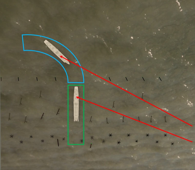
Figure 4. This diagram shows LCI(L)-94’s movement as it retracted from the beach. The highlighted boxes indicate the general locations of the ship when it was struck by the two enemy shells. (Author)
•
Similarly, from the location of the second hit, we can tell that when the ship was hit, it was pointed more or less directly at the sole surviving artillery piece in the WN62 strongpoint.[4] And in order to be pointed in that direction, the ship must have retracted 100-200 yards to clear the obstacle belt, and been in the process of turning when that shell hit home. That places Benchmark 3 within the blue highlighted box. We’ve now linked the two physical locations (Benchmarks 2 and 3) with the time 0850 hours (Benchmark 1).
According to both of Capa’s accounts, he was on deck when the ship was hit, but since he only noted one shell impact, we don’t know whether it would have been Benchmark 2 or 3. However, since the time between the hits appears to have been very short (“rapid succession”), the distinction isn’t critical.
•
Benchmark 4. This is located (in terms of space) by Capa’s own photos. In Slightly Out of Focus he stated, “I got up on deck again in time to take one last picture of the smoke-covered beach.” As noted above, he actually took two, and they both show the LCI heading east along the beach, in the process of turning back to the Transport Area. Figure 5 shows the LCI roughly 300 yards off the beach, and the group of tanks in Figure 2 were visible in the two photos taken from offshore. As a result, we can place Benchmark 4 within the red highlighted area in Figure 5.
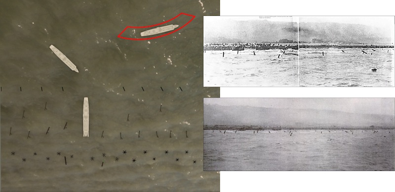
Figure 5. The red highlighted shape shows the approximate area where LCI(L)-94 was located when Capa took his two “one last shot of the beach” photos. The tanks visible in these two photos were directly ahead of the ship’s bow when it was beached. Note that all the activity shown in the diagram on the left occurred in an area only about 200 yards by 200 hundred yards, and within a span of just a few minutes. (Diagram by author)
We can’t place Benchmark 4 in time to a specific minute, but we can establish that it quickly followed Benchmark 3. During the process of retracting from the beach, the captain’s task was to pull the ship far enough off the beach to clear the obstacle belt, turn it around 180 degrees, and head back out to the Transport Area. When the first hit landed, the ship had not appreciably turned. Very quickly after that, when the second hit landed, the ship had already swung through an arc of about 45 degrees. Graham’s account continued:
I ran back to the steering engine room when the skipper (Gene R. Gislason, Lt. USCGR) yelled to me that the electric steering gear was out. Cody [Matthew Cody, MoMM2c[5]] was already down in the compartment. We changed over to hand steering. This switch took only a few seconds, then the ship swung around and was out of danger.”[6]
The important point here is that the ship was underway during this entire time. It did not wallow offshore, motionless, while damage-control measures were taken. So, from the moment the ship was first hit (Benchmark 1) until the ship swung around and began to head out to sea (Benchmark 4, when Capa took his “one last shot of the beach” photos) was a very short time — a matter of just a few minutes.
Benchmark 5 confirms this. Another Capa photo (Figure 6) shows his returning LCI passing LCT-305 as the latter was beginning its run into the beach. That LCT’s wave had been cleared to cross the Line of Departure at 0812 hours,[7] but LCT-305 could not find a gap in the obstacles and lingered inshore of the Line of Departure looking for a spot. At 0900 hours, as it finally neared the beach, the ship was hit by small-arms fire, badly wounding the officer in charge.[8]
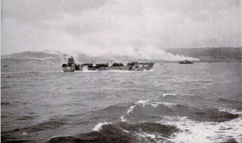
Figure 6. Capa’s photo of LCT-305 heading in for its run to the beach. The photo was taken inshore of the Line of Departure and before LCT-305 was hit by small arms fire at 0900 hours as it neared the beach.
From Figure 6 we can establish that LCT-305 was inshore of the Line of Departure, but still well outside of machine-gun range. This means that Capa and LCI(L)-94 encountered LCT-305 before the LCT was hit at about 0900 hours.
•
So all of the action between Benchmark 1 (0850 hours, when LCI(L)-94 was hit) and Benchmark 5 (when the two craft passed, shortly before 0900 hours) had to have taken place within roughly 10 minutes.
If we then deduct the time interval between when Capa took his last two shots of the beach until he encountered LCT-305, that leaves him just a very few minutes to shake off the effects of two close-by shell impacts, find his way to the engine room, dry off, smoke two cigarettes, do something with his film, then steel himself to return above decks and take those last shots of the beach. That’s a lot of activity to pack into … maybe 5 minutes?
•
And that brings us back to the matter of Capa’s head-to-toe drenching. Shortly after returning back above deck, Capa was filmed holding the slate board at the beginning of one of Ruley’s film reels. (Figure 7) In this clip, Capa showed absolutely no sign of his total immersion in the sea. His uniform consisted of wool shirt and pants and a cotton/poplin jacket with a flannel lining – none of which would have dried quickly on a cold, overcast day aboard a ship sprayed by the sea (most of the crew was wearing wet-weather gear).
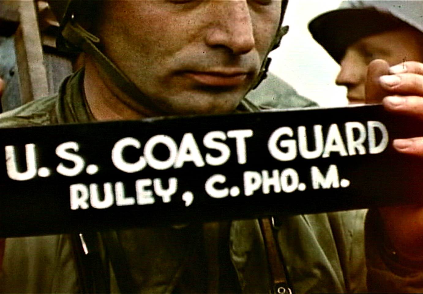
Fig. 7: Robert Capa holding cinematographer’s slate aboard LCI(L)-94, D-Day, frame from film by David T. Ruley
Nor is there any sign of the kapok debris that supposedly covered him. Surely, he could not have dried out so thoroughly, nor could he have so meticulously removed every speck of kapok from his clothes in that very brief time between Benchmarks 1/2/3 and 4. No. It’s simply impossible.
And that would seem to prove definitively that Capa’s account of his boarding is not accurate. There simply wasn’t time for him to go to the engine room, thoroughly dry off, smoke a couple of cigarettes, pick off all the kapok debris, change film (maybe?) and regain his composure in time to go back above decks and start taking pictures just off the beach. …
Notes:
[1] See Addendum 2 for an explanation of D-Day obstacles.
[2] Hendley, Pete. LCI-85: The Military Career of Lt(jg) Coit Hendley, Jr. During the Invasions of North Africa, Italy and Normandy on D-Day, His Papers and Photos. Yewell Street Press, Iowa City, Iowa, 2019, p. 210. Ironically, Coit Hendley was the captain of LCI(L)-85, which was shot up on the beach, and later that day sank alongside the USS Chase. Capa took at least one photo of the ship foundering alongside the Chase, and incorporated details of LCI(L)-85’s listing and sinking condition and applied them to LCI(L)-94, the ship that took him off the beach.With no ship left to command, Coit Hendley was posted to the staff of the LCI flotilla, which gave him the opportunity to briefly document the exploits of the flotilla’s LCIs on D-Day.
[3] Ruley, David T., “FILMING NORMANDY D-DAY,“ Movie Makers 20:6, June 1945, pp. 213, 228-30.
[4] It was at least the last artillery piece in the WN62 strongpoint covering this part of the beach. WN62 had another anti-tank gun still in operation at this point, but it was sited to cover the E-3 exit and could not bear on the LCI’s beaching spot.
[5] MoMM2c — Motor Machinist’s Mate 2nd Class.
[6] Op. cit.
[7] Action Report, Wave # Twelve (12), Dog Green Beach, Operation Neptune, Officer in Charge, LCT(5)-195, dated 14 June, 1944.
[8] Report of Serious Damage to Landing Craft Due to Enemy Action Damage Report, Commander, 18th LCT Flotilla, dated 11 July 1944; Noel, Larry. LCTs and LCT(A)s in Normandy D-Day, June 6, 1944 and Blegen, Robert. LCT(5) Flotilla 18 at Omaha Beach, June 6, 1944; both at the Landing Craft Tank WWII website (http://ww2lct.org/history/stories/). Peter Caddick-Adams’s Sand and Steel also cites LCT 305 After Action Report, dated 13 June 1944, but I haven’t been able to confirm this source.
•
Text copyright © 2023 by Charles Herrick. All rights reserved.
•
(For an index of links to all posts in this series, click here.)
•
 Charles Herrick joined the U.S. Army in 1970 and graduated from the U.S. Military Academy at West Point in 1974. Commissioned in the Infantry, he earned the Ranger tab and Master Parachutist’s wings. He served in a variety of positions from company grade officer to the Pentagon. He earned the Combat Infantryman’s badge while assigned as the Operations Officer of the 193rd Infantry Brigade in Panama in 1989, and later graduated from the U.S. Army War College.
Since retiring from the Army in 1996, Herrick has continued to work on defense issues as a contractor in East Asia, Latin America, the Balkans, Africa and Central Asia. He holds an MBA from the University of California at Los Angeles. He lives in California with his wife, where he pursues his passion for military history. To contact Charles Herrick, click here.

Leave a Reply